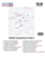
Site plan: EAASI companies at INTERGEO
- Sep 19, 2024
- 1 min read
Updated: Sep 20, 2024
INTERGEO is one of the most important events for the aerial mapping industry in Europe, and EAASI is pleased to participate once again.
To assist visitors in navigating the exhibition, we have created a detailed map showing the locations of EAASI members and observers with booths at the event. This will help industry professionals connect with key players and explore the latest developments in aerial surveying technology.
EAASI will organize two events on Wednesday 25th of September:
🔹 Wednesday, 10:30 AM: EAASI INTERGEO tour for students
🔹 Wednesday, 3:30 PM: EAASI Networking Event for industry professionals at the Geofly booth.
We invite you to take a look at the map and plan your visit accordingly.
Download the plan in pdf ⬇️
Hall 1
Kavel 10, Hall 1 B1.025
Teledyne, Hall 1 D1.002
Hexagon, Hall 1 E1.023
IGI, Hall 1 E1.044
Vexcel, Hall 1 F1.050 / F1.058
Geofly, Hall 1 F1.064
SOMAG, Hall 1 G1.002
Diamond Aircraft, Hall 1 G1.002
OPEGIEKA, Hall 1 G1.020
Milan Geoservice, Hall 1 H1.024
Zeusch Aviation, Hall 1 H1.017
Geolas Systems, Hall 1 L1.050
ITRES, Hall 1 L1.067
RIEGL, Hall 1 J1.024
ClearSkies Geomatics, Hall 1 J1.024
Hall 3
AVT Airborne Sensing, Hall 3 C3.014
BSF Swissphoto, Hall 3 C3.030
Flai, Hall 3 C3.016
Esri, Hall 3 D3.052
LasTools, Hall 3 C3.076
Phase One, Hall 3 C3.052 / C3.069
Hall 5
Dielmo, Hall 5 D5.017
Pythagoras, Hall 5 D5.057


